Chilly mornings are a sign of the blistering conditions that are to come for this weekend. Bundle up, folks -- Winter is coming to the Front Range!
I'm sure you've felt the temperature drop as the week continues. This is a sign of chillier weather to come. Radars are showing that a storm is brewing, and it aims to hit the west later this week -- hitting the mountains, of course, as well as the Front Range. By Wednesday, strong winds in the northern Rockies will officially bring the winter weather to the area. A "quick" period of snowfall across the Rockies and Front Range is in store, so says AccuWeather Meteorologist, Brett Rossio.
The snowfall isn't expected to be particularly inconvenient for those of us who need to get to work or school, but the storm is notable given the unusual way it will travel across the states.
[caption id="attachment_26008" align="aligncenter" width="538"]
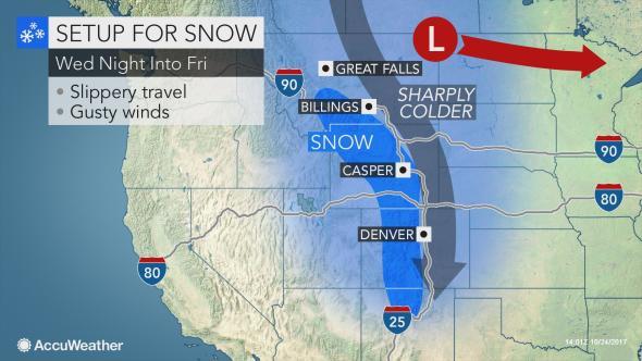 Photo courtesy of Accuweather[/caption]
The weather pattern is expected to hit Montana first, then Wyoming and the western Dakotas with snow and rain on Wednesday night. It will then travel down to Colorado, bringing snowfall Thursday evening. After that, the system will continue to travel south, downward along the Rockies, as opposed to across them.
This is amazing news as ski resorts are starting their seasons. This system will bring some much welcomed powder. As for the Front Range, residents of Fort Collins, Boulder, and Denver can expect a couple inches of snow before the Halloween weekend. The snow isn't expected to stick around for very long, but you may want to consider rethinking your costume to provide yourself with a bit more warmth.
Photo courtesy of Accuweather[/caption]
The weather pattern is expected to hit Montana first, then Wyoming and the western Dakotas with snow and rain on Wednesday night. It will then travel down to Colorado, bringing snowfall Thursday evening. After that, the system will continue to travel south, downward along the Rockies, as opposed to across them.
This is amazing news as ski resorts are starting their seasons. This system will bring some much welcomed powder. As for the Front Range, residents of Fort Collins, Boulder, and Denver can expect a couple inches of snow before the Halloween weekend. The snow isn't expected to stick around for very long, but you may want to consider rethinking your costume to provide yourself with a bit more warmth.
After the snowfall, the system will leave some remaining strong winds and chilly weather. This may bring along several issues, like power outages, or internet disturbances with strong enough wind events.
Are you excited for the snowfall and winter in general? We want to hear what you think!