Even with some seasonably cool morning lows, our daily mean temperatures have continued to run above average during the start of October, following a significantly warmer than average September. With only some afternoon cloud cover, and maybe a stray sprinkle tied to a
weak cold frontal passage , Friday’s highs in the low 70s will fade only to the upper 60s − still above the average of 65 − on a sunny Saturday. A ridge of high pressure will bring full sunshine and a light northeast breeze for a lovely start to the weekend.
The Buffalo skyline greets Sandy Long at the end of her walk at Chestnut Ridge in Orchard Park on Thursday, Oct. 3, 2024. Conditions are progressing to
view foliage colors , still nowhere near peak in most locations, but more colorful than last weekend. If you’re headed to Houston, count on some tailgating heat before you enter the covered stadium. A sunny sky will boost early afternoon highs to the low to mid-90s, with some discomfort from the humidity. Dew points in the upper 60s will feel sticky, but shy of the oppressive levels found all summer long in that steamy part of the country.
People are also reading…
Our Sunday will mark the beginning of a transition to a more autumnal pattern by Monday. The approach of two cold fronts will still allow time for warming to the mid-70s ahead of the
first front Sunday , well above average. However, the proximity of the afternoon cold front will trigger scattered showers and thunderstorms by afternoon. One of the limiting factors on thunderstorm intensity will be the lack of deep moisture in the lower atmosphere. Even so, there still may be a few stronger gusts with any storms.
This high-resolution model is more aggressive with faster timing of convection onset, by late morning/midday.
In this model , the bulk of the activity is past us by late afternoon, though other models do still present some sparse coverage showers still hanging in toward the dinner hour. Monday morning lows behind the first front will slip to seasonable upper 40s-low 50s. The deepening cool air will trigger some partial lake-effect cloud cover and a few
stray light showers , with Monday’s highs only in the low 60s. Tuesday and Wednesday will be the coolest days next week, with temperatures peaking in the mid- to upper 50s. The chilly northwest flow will produce a partly sunny sky both days, with a few light lake-effect showers possible. Morning lows may get cold enough to produce some isolated patchy frost in a couple of Southern Tier valleys, but nothing widespread. Thursday will be mostly sunny, and Friday looks to be dry as well with the
afternoon high returning to the low 60s , still a tad below average. By next weekend, the
ensembles show a colder upper level low will be pulling well away from our region, allowing a hint of moderating temperatures to rebuild across the Great Lakes. This won’t be unseasonable warmth, but readings may edge back to a little above average. However, by the following week,
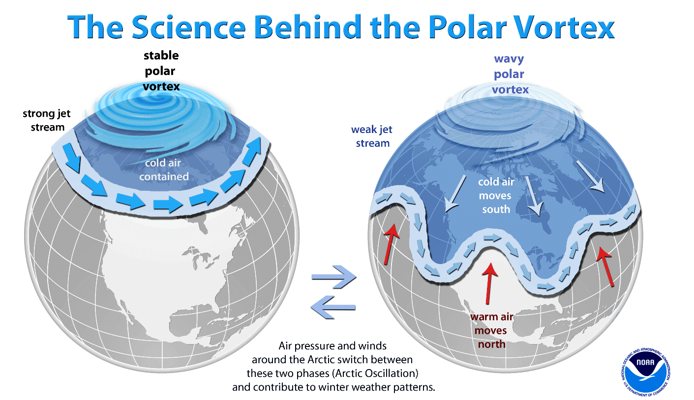
ensembles are showing the rebuilding of warm ridging in the West, forcing cooling troughing to return to the East. If this pattern verifies, this would produce a cooler-than-average pattern in the East on a northwest flow. How long this pattern may persist can’t be determined at this time. A respected private forecasting group based in Europe, Severe Weather-EU, has noted a weakened polar vortex will be developing at an unusually early time at upper, mid and lower levels next week. This would be more typical of later in the year, into the cold weather season. A weaker polar vortex can allow short, episodic wintry outbreaks most often in the central and eastern part of the country, since the polar jet stream can dive briefly southward during such episodes delivering harsh, wintry weather as was the case for one week back in January. This forecasting group believes this may be indicative of a greater likelihood of a weakened polar vortex later in the season, but their view is not yet widely held. Conversely, a strong
polar vortex tends to keep the polar air trapped in the polar regions, far to the north. In any case, what I’ve written here should not be taken as some kind of a winter outlook. It’s just too early, and is merely worth noting.
Is “climate change haven” image leading to complacency?
Some of us, myself included, have been propagating the idea that Western New York will end up being a region of much more resilience to the negative impacts on the accelerating warming of global climate. It is true we will remain less likely to suffer long-term droughts, widespread wildfires and life-threatening extreme heat. But we need to remember resilience does not equate to immunity. For one thing, there continue to be the risk of extreme winter weather events. The
Christmas weekend blizzard of 2022 took 47 lives and had ties to the rapidly warming arctic latitudes that appear to increase the frequency and amplitude of short-lived polar vortex disruptions to the south. While undergoing regional warming in the mean, these potentially deadly short-duration extreme events appear to be becoming more likely in otherwise milder winters, especially in December-January. We live in a wetter part of the country. The risk of flooding events has increased in wetter regions, as predicted by climate models in the 1980s. We do not have terrain comparable to the great elevation variations of western North Carolina where the devastating disaster continues to unfold. But the
terrain south of Buffalo has more than sufficient elevation changes to enhance the risk of flash flooding during excessive rainfall. Many
streams and creeks have headwaters in the hilly terrain to the south, meaning flow rates have in the past and will continue in the future to drastically increase during flood events. This was observed during the approaching of former Hurricane Agnes in June 1972. With such events becoming more likely in the warming environment, homeowners and lenders will need to pay greater attention to participating in the National Flood Insurance Program. The warming environment also includes the physical reality that warmer air holds more water vapor than cooler air. This means rainfall amounts will be increasing in such an environment, with more moisture to be wrung out of the atmosphere, particularly over hilly terrain. Parts of western North Carolina suffered rainfall totals of up to 30 inches on those mountainous locations, with 8-12 inches falling from a nontropical system before Helene even made its advance and eventual stall over Kentucky. Stalled inland storm systems, especially decaying tropical cyclones, are becoming more common in the warming climate, with its episodically weakened jet stream producing blocking patterns. This happened with devastating hurricanes Harvey near Houston in 2017, Florence in the Carolinas in 2018 and Helene last week. In research into the National Flood Insurance Flood Program, the Washington Post reported this week: “On average, just a tiny fraction of households in the inland counties hit hardest by Hurricane Helene and its remnants had flood insurance, according to a Washington Post analysis of recent data from the National Flood Insurance Program. Across seven affected states, only 0.8 percent of homes in inland counties affected by the storm had flood insurance. By contrast, 21 percent of homes in coastal counties in those areas had coverage.” Moreover, its research found many of the inland flood maps were based on badly outdated information. To be sure, flood insurance is costly. But homeowners insurance does not cover flooding, and to go without flood insurance means financial disaster for people whose homes are made unlivable or destroyed by flooding. Hopefully, flood maps in our region from the FEMA maps are not so out of date, and National Flood Insurance Program participation is greater here than in the stricken interior Southeast. A
2020 New York Times article covers the growing flooding risk, including for locations outside of FEMA flood zones, keeping in mind the situation has worsened since this article was written. Yes, our impacts from global warming will be somewhat mitigated in Western New York. But mitigation should not imply anything approaching immunity. Get the daily forecast and severe weather alerts in your inbox!
Get email notifications on {{subject}} daily!
